

Satellite Images: New Chinese settlement under construction near Pangong Lake
- In Reports
- 12:01 PM, Oct 15, 2024
- Myind Staff
India and China are continuing diplomatic talks to reduce tensions along their border. However, recent satellite images that surface in the media have shown that China is building a large settlement near the northern shore of Pangong Tso Lake.
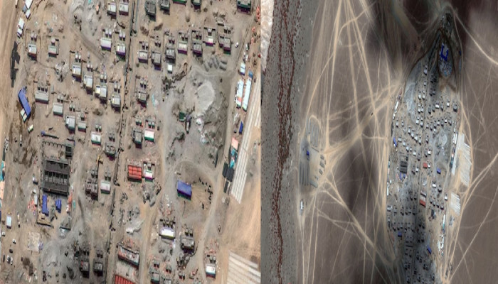
Although the settlement is outside of India's territorial claims, it is roughly 38 kilometres east of one of the locations where Indian and Chinese forces engaged in a standoff since 2020. Situated on the disputed border between China-administered Tibet and India, Pangong Tso is the highest saltwater lake in the world. On October 9, US-based Maxar Technologies took the satellite photos, which reveal fast-moving construction across roughly 17 hectares. The site, which is 4,347 meters above sea level and close to Yemagou Road, is a hive of construction and earthmoving activity.
Y Nithiyanandam, a professor and the head of the Takshashila Institution's Geospatial Research Program, states, "More than 100 buildings, including residential structures and larger administrative buildings, are being built. Open spaces and flattened land suggest possible future use for parks or sports facilities." Additionally, he indicated a rectangular strip in the southeast corner that was 150 meters long, suggesting that it might be ready for helicopter operations.
According to an analysis of accessible satellite imagery, work on a riverbed that slopes towards the lake started in early April 2024. Military sources claim that the settlement is separated into two sections, possibly denoting operational and administrative zones. The buildings' shadow analysis shows a variety of single- and double-storey structures, with smaller hutments close by that probably house six to eight people each. Administration and storage facilities could be housed in two larger structures. The arrangement, which is made up of staggered rows instead of straight lines, implies that the goal was to lessen susceptibility to long-range attacks.
The settlement's strategic advantage is further enhanced by its location behind high peaks, which reduces visibility from neighbouring areas. "The surrounding high peaks obscure the site from land-based surveillance equipment," said Nithiyanandam. According to military sources, if the settlement is utilised for military objectives, it might serve as an "adhoc forward base," which would shorten Chinese forces' reaction times.
Nature Desai, who studies the Indo-Tibetan border, offers a different view. He believes that the settlement might be meant for Tibetan nomads, pointing out that the site is Changzun Nuru, a historic campsite noted in the Central Asia Atlas by Swedish geographer Sven Hedin. Desai argues that the design of the settlement aligns more with the type of permanent homes the Chinese government has built for Tibetan nomads in the last twenty years, rather than the usual Xiaokang-style border defence villages.
If true, this would be the first settlement closure of its kind in the region, demonstrating China's continuous attempts to permanently settle Tibetan nomads. This development could be presented by China as "a long-awaited gift to its loyal nomads along the Indian frontier," according to Desai. While being close to a water source probably fixes problems with the water supply, Nithiyanandam noted that the settlement's energy requirements will probably be met by renewable sources.
Significant progress has been made over the last six months, and the quick pace of construction indicates that residential buildings are almost finished. However, severe weather in the upcoming months may affect the settlement's completion schedule.


Comments