


Satellite images indicate huge architectural wealth under iconic Bodh Gaya Temple
- In Reports
- 09:03 PM, Jul 13, 2024
- Myind Staff
A geospatial analysis, combining satellite imagery and ground surveys, has revealed substantial archaeological riches hidden beneath the Mahabodhi temple complex and its environs in Bodh Gaya, Bihar. This study was conducted jointly by the Bihar Heritage Development Society (BHDS), an arm of the state's Art, Culture, and Youth Department, in partnership with Cardiff University in the United Kingdom.
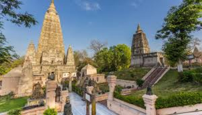
The Mahabodhi temple complex, recognised as a UNESCO World Heritage site, holds significant spiritual importance as one of the four sacred sites linked to the life of Lord Gautam Buddha. Bodh Gaya is renowned as the place where Lord Buddha is believed to have achieved enlightenment.
"The study has revealed evidence of substantial archaeological treasures lying beneath the soil of this UNESCO World Heritage site and its adjacent areas. This includes a wealth of architectural remains that warrant further excavation," stated Harjot Kaur Bamhrah, Additional Chief Secretary of the Art, Culture, and Youth Department.
The project, titled 'Archaeology on the footsteps of the Chinese traveller Xuanzang', is a collaborative effort between the UK-based university and the BHDS. MB Rajni, a faculty member from Bengaluru's National Institute of Advanced Studies and a member of the project team, examined satellite images of the Mahabodhi temple and its surroundings, endeavouring to align these findings with the accounts of Xuanzang.
The current Mahabodhi temple complex in Bodh Gaya includes the majestic 50-meter-high temple, the Vajrasana, the revered Bodhi tree, and six other sacred sites where Buddha attained enlightenment. Surrounding these are numerous ancient stupas, protected by concentric circular boundaries.
"BHDS, in collaboration with Cardiff University, has undertaken a multidisciplinary project tracing the archaeological path of the 7th-century Chinese monk and translator, Xuanzang, in Bihar. Recent satellite imagery reveals a series of buried structures aligned to the north of the temple," explained Bamhrah.
Notably, the images also document a significant geographical shift- the river Niranjana has migrated from an eastward to a westward course over time.
The Mahabodhi temple is situated to the west of the river, while the Sujata Stupa and other ancient remains are found to the east. Initially, these east bank monuments were considered separate from the Mahabodhi temple. However, recent discoveries suggest that both the temple and the Sujata Stupa, along with other archaeological sites, were originally located on the same riverbank. This finding is deemed highly significant by Bamhrah, indicating a strong likelihood that the monuments and archaeological remains currently on the east side of the river were once integral parts of the Mahabodhi complex.
BHDS plans to initiate research aimed at defining the boundaries of the Mahabodhi complex in light of recent discoveries. They intend to conduct a new ground-penetrating radar (GPR) survey, followed by excavation efforts to uncover buried archaeological features identified in satellite images.
According to BHDS Executive Director Bijoy Kumar Choudhary, the latest study has revealed several notable findings. These include a square monastery complex north of the temple, enclosed by a wall with a surrounding moat, as well as an extended settlement to its north.
Xuanzang, also known as Huien Tsang, was a Chinese Buddhist monk, scholar, traveller, and translator renowned for his journey to India from 629 to 645 CE. His writings played a crucial role in Alexander Cunningham's identification of significant Indian sites like Nalanda and Vaishali in the 1860s and 1870s.
The square wall surrounding the monastery complex is particularly intriguing, having been excavated by Cunningham in the 19th century, though no subsequent excavations have taken place. This area holds considerable promise for future systematic excavation efforts.
"After analysing satellite images, we identified two concentric squares- an outer square encompassing 4.9 acres and an inner square encompassing 2.5 acres. There is a gap of approximately 15 meters between the outer and inner squares, extending to about 20 meters in the east and west directions," stated Rajni in the report. "While the monastery's physical remnants are no longer visible on the ground, satellite imagery indicates significant overlap of these squares with the Samanvay Ashram," Rajni informed.
"In particular, the well observed by Cunningham at the centre of the monastery's pillared court may correspond to one of the two wells found within the Ashram, situated south of the statue of Dwarkoji Sunderani," she elaborated. Rajni added, "The southern boundary of the Ashram, delineated by a compound wall atop a raised ridge, aligns with the southern boundary of the outer square, suggesting the presence of buried remnants of an earlier wall."
Image Source: Money Control


Comments