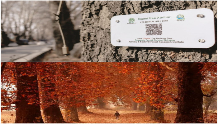
Kashmir's iconic chinars digitally protected through geo-tagging and QR codes
- In Reports
- 01:46 PM, Jan 22, 2025
- Myind Staff
In an effort to preserve its rich heritage, the iconic Chinar trees in Kashmir have been digitally safeguarded through geo-tagging and QR codes. This conservation project, led by the J&K Forest Research Institute (FRI) under the J&K Forest Department, focuses on monitoring and managing these heritage trees using modern technology.
According to Dr. Syed Tariq, Project Coordinator at FRI, the initiative began in 2021. "We have surveyed Chinars across the Valley, and so far, we have geo-tagged 28,500 of them," he stated. Each Chinar tree has been equipped with a QR-based digital plate, affixed using a specially designed spring-enabled metal.
"There is complete information about the specific Chinar tree in the QR code. One can show the code and get instant information about the tree," Dr. Tariq explained. By scanning the QR code, individuals can access detailed data about the Chinar tree, such as its location, health status, age, and other essential characteristics.
“We aim to create a robust system for monitoring the iconic Chinar trees and addressing threats proactively. It will give digital protection to them,” Tariq said. Known locally as Boueen and scientifically as the maple tree, the Chinar is a hallmark of Kashmir's landscape in nearly every corner of the Valley.
The Ganderbal district of central Kashmir has the largest Chinar tree larger than the largest Chinar tree previously declared in Asia. Kashmir also has the world's oldest 647-year-old Chinar, located in Chattargam village in Budgam district of central Kashmir. The Chinar tree, believed to have been introduced to Kashmir from Persia, can grow to a height of up to 30 metres with a girth of 10 to 15 meters at its base. It takes approximately 150 years for a Chinar to reach its full size. Dr. Tariq mentioned that once a complete database of Chinars is compiled, a dedicated website for the Chinar trees will be developed.
“It will have all the information about the chinars. Everybody can log in. Even our administration can easily assess which chinar has dried up and which is dangerous. We are proposing more surveys on risk assessment. It is a USG-based risk assessment survey. It will be done through machines, and there will be no human interference. It will give us information whether the tree is safe or risky,” he conveyed.


Comments