

Iran used Chinese satellite to monitor US bases in Middle East: FT report
- In Reports
- 06:46 PM, Apr 15, 2026
- Myind Staff
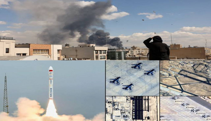
Iran used a Chinese-built satellite to monitor United States military bases in the Middle East during the recent conflict, according to a report by the Financial Times published on Wednesday. The satellite, known as TEE-01B, was developed and launched by a Chinese company called Earth Eye Co. It was reportedly purchased by the Aerospace Force of Iran’s Islamic Revolutionary Guard Corps (IRGC) in late 2024, shortly after it was sent into space.
The report is based on leaked Iranian military documents. These documents suggest that Iranian commanders used the satellite to closely observe key US military sites across the region. The monitoring reportedly took place both before and after missile and drone strikes carried out by Iran. The Financial Times stated that the evidence includes time-stamped coordinates, satellite images, and orbital tracking data, which together show how the satellite was used during the operations.
The satellite is said to have captured images of several important locations. Among them was the Prince Sultan Air Base in Saudi Arabia. According to the report, images of this base were taken on March 13, 14, and 15. On March 14, US President Donald Trump confirmed that American aircraft stationed at the base had been hit. The timing of the satellite images suggests that Iran may have used this data to assess the impact of its strikes.
In addition to Saudi Arabia, the satellite also reportedly tracked other strategic sites. These included the Muwaffaq Salti Air Base in Jordan, areas near the US Fifth Fleet naval base in Manama, Bahrain, and the airport in Erbil, Iraq. These locations were reportedly monitored around the same time Iran claimed responsibility for attacks in those areas. The data indicates a coordinated effort to observe and evaluate military targets across multiple countries in the region.
As part of the satellite deal, Iran is also believed to have gained access to a network of commercial ground stations. These stations are operated by Emposat, a Beijing-based company that provides satellite control and data services. The company’s network spans across Asia, Latin America, and other regions. This access likely helped Iran receive and process satellite data more efficiently during the conflict.
Despite the detailed claims in the report, Reuters stated that it could not independently verify the findings. Several key parties have not responded to requests for comment. These include the White House, the CIA, the Pentagon, China’s foreign affairs and defence ministries, as well as Earth Eye Co and Emposat. The lack of official confirmation leaves some uncertainty around the full extent of the satellite’s use.
Earlier reports had already suggested that Iran received satellite intelligence from Russia during the conflict. This intelligence reportedly included images of US and Israeli targets after the US-Israeli bombing campaign against Iran began on February 28. That campaign aimed to weaken Iran’s regime and disrupt its ballistic missile and nuclear programs.
The situation escalated further when Iran launched missile and drone attacks across the region in response. It also moved to block the Strait of Hormuz, a crucial route for global oil shipments. The conflict saw a temporary pause after a two-week ceasefire was announced last Wednesday. During this period, Russia and China vetoed a United Nations Security Council (UNSC) resolution to reopen the Strait and ease tensions.
The report highlights how satellite technology is becoming a key tool in modern warfare. It also raises concerns about the role of international partnerships in military operations and intelligence gathering.


Comments