


Indian map with PoK, Aksai Chin released by US Trade Representative office grabs attention
- In Reports
- 06:56 PM, Feb 07, 2026
- Myind Staff
As India and the United States announced the framework for an interim trade agreement, a map released by the Office of the United States Trade Representative (USTR) drew widespread attention and discussion. The graphic accompanying the USTR’s announcement showed all of Jammu & Kashmir and Ladakh, including Pakistan-occupied Kashmir (PoK), and the Aksai Chin areas, which are subject to long-standing territorial disputes, as part of Indian territory, catching the eye of observers and commentators.
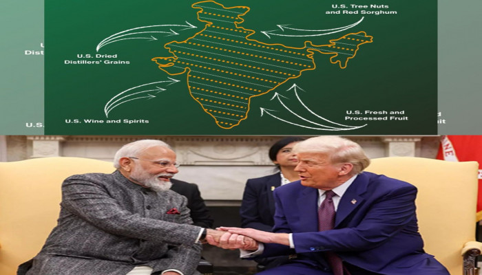
The map was shared alongside the details of the interim trade deal framework that was jointly announced by officials from both countries. In the post on X (formerly Twitter), the US Trade Representative’s office said, “From tree nuts and dried distillers’ grains to red sorghum and fresh and processed fruit, the US-India Agreement will provide new market access for American products.”
The graphic accompanying this message featured a depiction of India that included the entire Jammu & Kashmir region, including Pakistan-occupied Kashmir, as well as Aksai Chin, which is claimed by China. Typically, previous maps released by the US government have shown these areas differently, often marking PoK separately as disputed. The representation in the recent map, therefore, stood out as unusual and drew attention due to the sensitive nature of the territorial claims involved.
While India has always maintained that Jammu & Kashmir, along with Ladakh, is an integral part of the country and does not require external validation of its sovereignty, the map’s depiction was seen as a shift from earlier US map practices. The article noted, “While India has consistently maintained that Jammu and Kashmir is an integral part of the country and does not require external validation of its sovereignty, the depiction marks a departure from earlier US government maps, which typically showed the other claims as a part of the map.”
The timing of the release is especially notable because it comes as India and the United States aim to strengthen their trade ties after months of talks and negotiation. Earlier in the year, the Trump administration had imposed a 50% tariff on Indian goods, including additional tariffs on Russian oil imports — the highest tariff rate imposed on a US ally at the time. Under the interim framework that was announced, the tariff is set to be reduced to 18%, making it one of the lowest among Asian nations.
Although the USTR did not explicitly comment on the map itself, its inclusion alongside the trade agreement announcement was interpreted by many as carrying a subtle diplomatic message, particularly concerning long-running tensions between India and Pakistan over territorial issues. The article described the map release as “an embarrassment for Pakistan, which claims PoK,” and highlighted that it came during a period of sustained diplomatic outreach by Pakistan to Washington, including several visits by Pakistan’s Prime Minister Shehbaz Sharif and army chief Asim Munir, along with meetings involving US leadership.
In the context of ongoing geopolitical dynamics, the map’s reception has sparked commentary on social media and in political circles. Many saw the depiction as aligning with India’s position on its territorial claims, even though India’s official position has consistently been that its claims stand independently of external cartographic validation.
The interim trade pact that was referenced with the map is expected to be officially signed by mid-March and is aimed at easing trade tensions and providing relief to Indian exporters after months of uncertainty. Along with the tariff reductions on Indian goods, the deal is intended to strengthen economic ties and open up new market access for US products.
Overall, while the trade agreement’s economic aspects remain a central focus, the map shared by the US Trade Representative’s office has generated its own level of attention and discussion due to the inclusion of disputed areas within India’s borders — a depiction that is closely tied to India’s territorial claims and the sensitive diplomatic relationships with its neighbours.


Comments