




India–Myanmar Border Dispute & the Proposed Land Swap in Manipur
- In Military & Strategic Affairs
- 01:28 PM, Aug 12, 2026
- Lt Gen L N Singh (Retd)
Introduction
The India–Myanmar border has once again become a subject of controversy following reports of a possible land adjustment between the two countries in Manipur's Chandel district. The controversy emerged after ‘The Diplomat’, an American Publication, reported on July 17, 2026, citing an internal Indian government document, that India and Myanmar were considering a final demarcation of an approximately 2.75–2.8 kilometre stretch between Border Pillars 65 and 68. The report suggested that around 3.5 square kilometres, or approximately 1.4 square miles, of land could be involved in a possible land swap.
For Manipur, any alteration or compromise in its territorial integrity is an existential threat. The report, therefore, generated considerable concern in Manipur, where territorial integrity, identity and the international border are highly sensitive. However, the Ministry of External Affairs (MEA) has not confirmed that any land has been transferred or that a land-swap agreement has been finalised. MEA spokesperson Randhir Jaiswal stated that only certain portions of the India–Myanmar border remain unsettled and that discussions regarding their demarcation are continuing.
Historical Background
The Kabaw Valley Question - The history of the India–Myanmar border is closely connected with the colonial period and the Kabaw Valley.
During the First Anglo-Burmese War of 1824–1826, the British interest in the region increased. Following the Treaty of Yandabo in 1826, the British redrew the boundary through what became known as the Pemberton Line. The Pemberton Line is an 1834 British-demarcated boundary between the kingdom of Manipur and Burma (Myanmar) and placed the Kabaw Valley under Burmese administration.
As part of this arrangement, the King of Manipur was compensated with 500 silver coins regularly. This compensation arrangement continued for more than a century. In 1953, after Indian independence, Prime Minister Jawaharlal Nehru and Burmese Prime Minister U Nu agreed to discontinue the payment.
The Present Border Issue
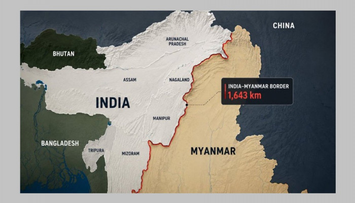
India and Myanmar share an international border of approximately 1,643 kilometres, passing through Arunachal Pradesh, Nagaland, Manipur and Mizoram on the Indian side. The region opposite to Manipur is Myanmar's Sagaing Region and Chin State.
Although India and Myanmar signed a border agreement in 1967, the exact demarcation of every portion of the boundary on the ground was not completed. According to the material provided, boundary pillars have been installed along approximately 1,472 kilometres, while around 171 kilometres remain unsettled or not completely demarcated.
Among the sensitive sectors in Manipur are:
Molcham Sector: between Border Pillars 64 and 68
Moreh Sector: between Border Pillars 75 and 79
Choro Khunou Sector: between Border Pillars 88 and 95
The particular stretch currently attracting attention lies between Pillars 65 and 68 in Chandel district, adjacent to Kabaw Valley. The issue, therefore, relates primarily to the precise identification and demarcation of an already agreed international boundary rather than the creation of an entirely new border.
The Reported Land-Swap Proposal
According to the reported information, India and Myanmar are considering a possible adjustment involving approximately 3.5 square kilometres of land in the 2.75–2.8 kilometres stretch between Pillars 65 and 68.
However, an important distinction must be made between a proposal or discussion and a finalised agreement.
The MEA has acknowledged that discussions concerning unresolved sections of the border are taking place, but it has not officially confirmed a land transfer. According to the material provided, there has been no finalised land-swap agreement; no reported Cabinet approval; no proposal formally placed before Parliament; and no official confirmation regarding the transfer of Indian territory to Myanmar.
Therefore, describing the present situation simply as India "handing over Manipur's land" would go beyond what has been officially confirmed.
Why Is Demarcation Needed?
1 Border Security:
One of the primary reasons is national security. India has been planning to fence the entire India–Myanmar border and construct patrol roads. Hence, an undisputed boundary is essential before fencing is done.
The security situation along the border is complicated following Myanmar's 2021 military coup. Reportedly, nearly 79,000 refugees entered India, while concerns regarding militant movement, drug trafficking, weapons smuggling and other forms of cross-border crime.
2. Ending or Restricting the Free Movement Regime
Historically, communities living along the India–Myanmar border had considerable freedom of movement across the frontier. The Free Movement Regime (FMR) allowed people living close to the border to cross without visa within a specified distance.
In February 2024, citing security concerns, the Central Government announced the termination of the FMR and began pursuing stronger border fencing. Demarcation is needed for border fencing.
3. Strategic Relations with Myanmar
Myanmar is strategically important for India because it is India's only land neighbour in Southeast Asia and plays an important role in the Act East Policy.
Major connectivity projects such as the India–Myanmar–Thailand Trilateral Highway and the Kaladan Multi-Modal Transit Transport Project are linked to India's wider effort to connect the Northeast with Southeast Asia.
At the same time, India has security interests involving militancy, narcotics, arms smuggling and cross-border crime. Consequently, the India–Myanmar border is important not only for Manipur but also for India's broader foreign policy and national security interests.
This has created a fundamental tension. From the perspective of the Central Government, fencing and clearly defining the border are measures aimed at strengthening security.
But some oppose the fencing. The Mizoram Legislative Assembly passed a resolution in February 2024 opposing the termination of the FMR and border fencing.
Opposition from Manipur Civil Society on Land Swapping
The issue has also received strong opposition from COCOMI — the Coordinating Committee on Manipur Integrity, an umbrella organisation representing Meitei civil society groups.
COCOMI has argued that no portion of Manipur's historical territory should be surrendered to Myanmar. Its position is rooted in concerns that any compromise of the territorial integrity of this tiny state is an existential threat to Manipur. There is a fear that accepting even a small territorial adjustment could establish a precedent for future changes.
The sensitivity has increased considerably following the conflict between Meitei and Kuki-Zo communities that began in 2023. In this environment, questions concerning illegal migration, militancy, border security and demographic change have become especially politically sensitive.
Thus, the controversy has evolved beyond a technical question of boundary demarcation. For many in Manipur, it is connected with questions of identity, historical territory, political representation and the integrity of the state.
The Constitutional and Legal Dimension
An important aspect of the controversy is that an international boundary cannot simply be altered through an informal administrative decision.
Compare the situation with the 2015 India–Bangladesh Land Boundary Agreement, under which India transferred 111 enclaves to Bangladesh and received 51 enclaves. It involved extensive parliamentary discussion and a constitutional amendment.
Therefore, this too would require appropriate legal, constitutional and diplomatic procedures. Technical surveys and border-commission recommendations would also be relevant before any final settlement could be implemented.
Thus, any settlement along the Myanmar border would need to be transparent, involve the confidence of local communities and take into account Myanmar's continuing political instability and civil conflict.
The Role of the 2026 Diplomatic Talks
The issue also gained importance following the visit of Myanmar's military ruler Senior General Min Aung Hlaing to India from 30 May to 3 June, 2026.
During the visit, border-related issues and the installation of auxiliary boundary pillars were discussed. A proposal dating back to 2017 concerning demarcation in the Molcham sector was also revisited.
Hence, the present discussions are part of a longer-running process to resolve sections of the India–Myanmar boundary that remain undemarcated.
The Central Question: Land Transfer or Boundary Demarcation?
The most important distinction in understanding the controversy is between land transfer and boundary demarcation.
A land transfer implies that territory clearly belonging to one country is formally given away to another. Boundary demarcation, on the other hand, involves determining and marking the precise location of an international boundary that may already have been established in principle but remains unclear on the ground.
The reported proposal concerning the area between Pillars 65 and 68 may involve a land adjustment, but it has not been finalised by the Indian government. Therefore, the claim that India has already decided to hand over a portion of Manipur to Myanmar is not supported by the official position available.
Key Challenges Ahead
The future resolution of the issue will have to balance three major concerns:
First, national security. India wants a clearly demarcated and effectively monitored border to address illegal movement, militancy, drug trafficking and other security challenges.
Second, diplomacy. Myanmar remains strategically important to India's regional and Act East policies. Maintaining workable relations with Myanmar is therefore important.
Third, public confidence in Manipur. Any perceived alteration of Manipur's territory can generate strong political opposition.
The challenge for policymakers is therefore not merely to determine where a boundary should run, but to create a settlement that is legally sound, diplomatically acceptable, strategically secure and publicly credible.
Conclusion
The India–Myanmar border controversy in Manipur is a complex intersection of history, territory, national security, diplomacy and local identity.
Reports have suggested that a land adjustment involving approximately 3.5 square kilometres may be considered. However, the Indian government has so far confirmed only that discussions regarding unresolved sections of the border are continuing.
The issue therefore should not be understood simply as a case of India "giving away" land. It is part of a much longer process of completing the demarcation of the India–Myanmar boundary.
At the same time, the concerns expressed in Manipur cannot be dismissed as merely political.
Ultimately, any future settlement will need to strike a careful balance between secure borders, stable India–Myanmar relations, constitutional procedures and the trust of the people living in the border region. Transparency and consultation with affected communities will be essential if a durable solution is to be achieved. The coming months will therefore be important in determining whether the current discussions develop into a formal agreement or remain part of the long-standing process of border demarcation.



 Loading...please wait
Comments