


China extensively maps ocean floor bed as it prepares for underwater warfare with US
- In Reports
- 05:34 PM, Mar 30, 2026
- Myind Staff
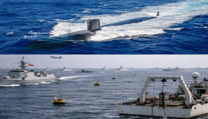
China has carried out a large and coordinated effort to strengthen its underwater warfare capabilities by deploying a network of 42 research vessels along with hundreds of oceanic sensors. This multi-year operation spans across the Pacific, Indian, and Arctic oceans. Its main aim is to collect detailed data about the ocean floor and underwater conditions. This information can directly support submarine operations, especially in regions where the United States and its allies maintain a strong naval presence.
The campaign focuses on mapping the seabed and monitoring ocean conditions in real time. These activities help improve underwater navigation, concealment, and sonar performance. The areas covered include key maritime routes and chokepoints such as waters near Taiwan, Guam, and the Malacca Strait. These locations are strategically important for naval movement and military operations. By gathering precise environmental data, China is building a system that allows its submarines to operate more effectively in contested waters.
The data collected includes seabed terrain, water temperature, salinity, and ocean current patterns. All these factors influence how submarines move and how sonar systems perform. When submarines operate underwater, sound behaves differently depending on these conditions. With accurate knowledge, submarines can avoid detection or track enemy vessels more efficiently. This gives a significant advantage in both defensive and offensive operations.
The project has been underway for more than five years. It involves not just moving ships but also placing sensors in critical locations. These sensors are positioned along major naval routes and chokepoints. They continuously record environmental changes instead of capturing data at a single moment. This creates a long-term and reliable dataset that can be used for planning submarine missions.
Although many of these missions are officially described as civilian research, such as climate studies or seabed sampling, the data collected have clear military value. This reflects China’s approach of combining civilian and military efforts. Research vessels are used to gather information that can later support naval strategies. This integration allows continuous data collection without raising immediate concerns.
One example of such activity is the Chinese research vessel Dong Fang Hong 3. It carried out several survey missions between 2024 and 2025 in different regions. These included waters near Taiwan, areas around Guam, and parts of the Indian Ocean. The ship returned to some locations more than once. This suggests that the work was systematic and not exploratory. In October 2024, it examined seabed sensor systems near Japan that could detect underwater movement. It returned to the same area in May 2025, likely for recalibration or data retrieval.
In March 2025, the vessel conducted detailed surveys between Sri Lanka and Indonesia. This region covers important routes leading to the Malacca Strait. These routes are vital for global trade and energy transport. The repeated presence of the vessel in these areas shows a focused effort to map and monitor important maritime corridors.
The survey methods used by Chinese vessels involve moving in parallel lines across the ocean. This ensures that there are no gaps in the data collected. Such techniques produce high-resolution maps of the seabed. These maps include depth levels, sediment types, and physical features like ridges and slopes. These details are crucial for submarine movement and for understanding how sonar signals reflect underwater.
At least eight vessels have been involved directly in seabed mapping, while ten others have similar capabilities. This shows that the ability to collect such data is spread across multiple ships. Repeating surveys in the same areas helps improve accuracy. Over time, simple maps turn into detailed environmental models that can support advanced military planning.
The sensor network plays an equally important role. These sensors are placed on the seabed, attached to buoys, or arranged in underwater arrays. They are located in regions east of Japan, near the Philippines, around Guam, and in parts of the Indian Ocean. Some are positioned near Sri Lanka and along the Ninety East Ridge. These systems measure temperature, salinity, currents, and even detect underwater movement.
This continuous monitoring helps track changes in ocean conditions. It allows for better prediction of how sound travels underwater. Sound propagation is affected by temperature layers, salinity differences, and pressure. These variations can create zones where sound waves bend or weaken. Such zones can either hide submarines or expose them. By understanding these patterns, submarines can position themselves in areas where detection is difficult.
The combination of seabed mapping and water data creates a complete picture of underwater conditions. This helps submarines plan safe routes, avoid obstacles, and remain hidden. It also improves anti-submarine warfare by enhancing detection accuracy. Sonar systems can be adjusted based on local conditions, increasing their effectiveness.
This detailed knowledge also allows China to identify likely submarine routes used by other nations. Sensors can then be placed in these areas for better monitoring. This creates a system of persistent surveillance in key maritime corridors. Such capabilities are especially useful in regions where the U.S. Navy operates frequently.
China’s mapping activities are focused on areas of high strategic value. These include the First Island Chain, waters near Taiwan and Guam, and regions around Hawaii and Wake Atoll. These locations are close to major U.S. military bases and naval routes. Additional efforts in the Indian Ocean and Arctic suggest a long-term plan to cover emerging strategic regions as well.
Overall, this large-scale effort represents a shift toward data-driven underwater operations. By combining repeated surveys with continuous monitoring, China is building a reliable and detailed understanding of global ocean environments. This reduces uncertainty in submarine missions and improves both navigation and detection capabilities.
The integration of civilian research with military use ensures a steady flow of data. Over time, this approach strengthens China’s underwater warfare capabilities. It also acts as a force multiplier for its submarine fleet, which is expected to grow significantly in the coming years. This development marks an important step in the evolving balance of naval power.


Comments