Where is the Mahendra Parvat of Ramayana?
- In History & Culture
- 01:10 PM, Jul 28, 2022
- Jeevan Rao
This is the second article in the series “Geography of Ramayana”. In the first part, I have identified the location of the Jatayu’s fall. In this sequel, we shall try to find the location of Mt. Mahendra, which was Bhagwan Hanuman’s take-off point for Lanka. The series aim is to use all these locations to connect the missing dots, culminating in finding the location of Ravana’s Lanka.
Ramayana mentions that from Mt. Mahendra, Bhagwan Hanuman crossed the ocean for ~100 Yojanas before reaching Lanka, in his search for Sita. A large number of people consider Mahendragiri of present-day Odisha as the Mt. Mahendra from where Hanuman left for Lanka, due to the following reasons:
- The aerial distance from Odisha’s Mahendragiri to present-day Sri Lanka is approx. 800 miles.
- The popular definition of 1 Yojana = 8 miles makes the distance from Mahendragiri to Sri Lanka 100 Yojanas.
Is the distance of 800 miles between Mt. Mahendra and Lanka a sufficient criterion to identify Mahendragiri of Odisha with Mt. Mahendra?
Luckily for us, Ramayana has left an impressive amount of information related to the location of Mt. Mahendra, which should clear the ambiguity regarding its present-day location.
The Vanara King Sugreeva while dispatching his troops in all directions to search for Sita, gives an encyclopaedic description of the terrains the Vanaras would encounter in their path. Likewise, while sending the group of selected Vanaras consisting of Angada, Hanuman and Jambavanta in the Southern direction, he starts by describing the regions of Central India, namely, the Vindhyas and their surroundings.
सहस्र शिरसम् विंध्यम् नाना द्रुम लता आयुतम् |
नर्मदाम् च नदीम् रम्याम् महोरग निषेविताम् || ४-४१-८ ८
"Search the thousand crested Vindhya mountains abounding with numerous tress and climbers, then the delightful Narmada River coursing a little southerly to that range, which is adored by great snakes.” [4-41-7]
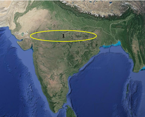
Then Sugreeva describes the region to the south of Vindhyas, which encompass most of the present-day Maharashtra and Orissa.
ततो गोदावरीम् रम्याम् कृष्णावेणीम् महानदीम् |
वरदाम् च महाभागाम् महोरग निषेविताम् |
मेखलान् उत्कलाम् चैव दशार्ण नगराणि अपि || ४-४१-९
अब्रवंतीम् अवंतीम् च सर्वम् एव अनुपश्यत |
विदर्भान् ऋष्टिकान् चैव रम्यान् माहिषकान् अपि || ४-४१-१०
“Search the areas along the wonderful River Godavari, as well as River Krishnaveni and Maha Nadi, and then the greatly auspicious River Varada which is adoration to great snakes. And the territories of Mekhala, Utkala, the cities of Dashaarna, kingdoms of Abravanti, Avanti, and Vidarbha, also thus the charming kingdom of Maheeshaka, are to be searched thoroughly.” [4-41-9, 10]
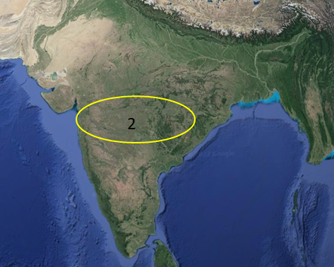
Continuing with his narration Sugreeva states,
तथा वन्गान् कलिन्गाम् च कौशिकान् च समंततः |
अन्वीक्ष्य दण्डक अरण्यम् स पर्वत नदी गुहम् || ४-४१-११
नदीम् गोदावरीम् चैव सर्वम् एव अनुपश्यत |
तथैव आन्ध्रान् च पुण्ड्रान् च चोलान् पाण्ड्यान् केरलान् || ४-४१-१२
"Like that Vanga, Kalinga territories shall be searched along with Kaushika territories available on their fringes, then cast about the Dandaka forest all over its mountains, rivers, and its caves, then River Godavari that courses through Dandaka forest, and then the provinces of Andhra, Pundra, Chola, Paandya, Kerala are to be searched thoroughly.” [4-41-11, 12]
Something very interesting has been embedded here in Sugreeva’s statement. When he mentions Paandya and Kerala, he is not repeating the mention of the same geographical location viz. present-day Kerala twice. Instead, Sugreeva uses the term Kerala to denote the west coast of India spanning from Gokarna to Kanyakumari. Why do I say that?
Legend has it that, Parasurama, an avatar of Vishnu, threw his battle axe into the sea after he reached Gokarna and it landed at Kanyakumari, this entire region of land was known as Kerala1.
We find corroboration for this identification of Kerala from within the Ramayana itself. After mentioning Kerala, Sugreeva mentions mountain ranges, iron-ore mines, Sandalwood trees and river Kaveri in the same order.
अयोमुखः च गंतव्यः पर्वतो धातु मण्डितः |
विचित्र शिखरः श्रीमान् चित्र पुष्पित काननः || ४-४१-१३
सुचंदन वनोद्देशो मार्गितव्यो महागिरिः |
तत्र द्रक्ष्यथ कावेरीम् विहृताम् अप्सरो गणैः |
"You shall go to the prosperous Mt. Malaya which is crowded with iron-ore mines as its vast mouths, and with amazing crests and motley flowered forests. The search shall be carried out on that great mountain in the places that are with the copses of sandalwood trees. From there you shall go and see the divine River Kaaveri.” [4-41-13, 14a, 15a]
Any guess where the iron ores are primarily concentrated in India?
Yes, along the Western coast/parts of India.
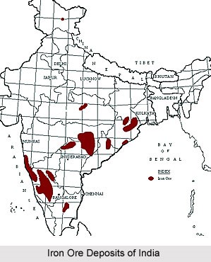
The description given by Sugreeva matches perfectly for anyone travelling from the Western Ghats, through the heartland of Karnataka (Bellary, Mysore etc.) in a North to South direction.
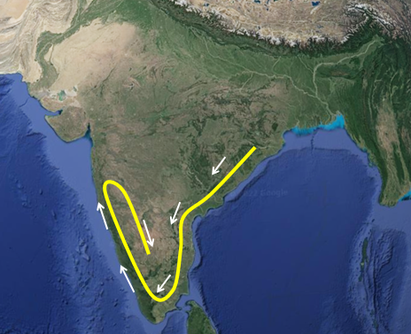
Sugreeva continues to narrate the journey southwards, till the station of Agasthya along the Malaya ranges.
तस्य आसीनम् नगस्य अग्रे मलयस्य महोजसम् || ४-४१-१५
द्रक्ष्यथ आदित्य संकाशम् अगस्त्यम् ऋषि सत्तमम् |
"You shall see the eminent sage Agastya, whose resplendence is akin to that of the Sun, and who will be sitting on the top of that highly resplendent Mt. Malaya.” [4-41-15b, 16a]
The memory of this station of Agasthya has been preserved to this day in the name of the mountain “Agasthyamalai” in Tamil Nadu. This mount/station of Agasthya is a crucial point in determining the location of Mt. Mahendra.
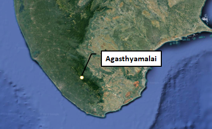
Sugreeva provides another critical piece of evidence when he says, the river “Taamraparni” flows nearby the station of Agasthya.
ततः तेन अभ्यनुज्ञाताः प्रसन्नेन महात्मना || ४-४१-१६
ताम्रपर्णीम् ग्राह जुष्टाम् तरिष्यथ महानदीम् |
"And when that great-souled Agastya complaisantly permits you, then you shall leave that mountain and cross over the great River Taamraparni, a highly cherished river of crocodiles.” [4-41-16b, 17a]
It is incredible to note that the river Taamraparni does originate from the present-day “Agasthyamalai”, corroborating Sugreeva’s description.
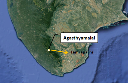
Sugreeva then instructs the Vanara party to enter the Pandyan Kingdom to search for Sita. Pandya region could be estimated to be in the southern part of the Indian mainland.
ततो हेममयम् दिव्यम् मुक्ता मणि विभूषितम् || ४-४१-१८
युक्तम् कवाटम् पाण्ड्यानाम् गता द्रक्ष्यथ वानराः |
"From there on, going to the Paandya Kingdom you shall see a fully golden castle door bracing the compound wall of the fortress, which is decorated with pearls and jewels, and conduct your search even in that kingdom.” [4-41-18b, 19a]
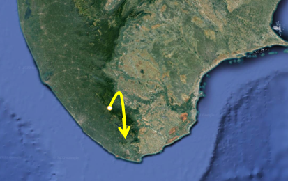
It is in this southernmost region that Sugreeva informs the Vanara Party of the location of Mt. Mahendra.
ततः समुद्रम् आसाद्य संप्रधार्य अर्थ निश्चयम् || ४-४१-१९
अगस्त्येन अन्तरे तत्र सागरे विनिवेशितः |
चित्र सानु नगः श्रीमान् महेन्द्रः पर्वतोत्तमः || ४-४१-२०
"Then on reaching the ocean, and on taking a resolution about the purpose of your task, viz., the importance of the mission undertaken, you reach the glorious Mt. Mahendra.” [4-41-19b, 20]
Now compare these descriptions for Orissa’s Mahendragiri.
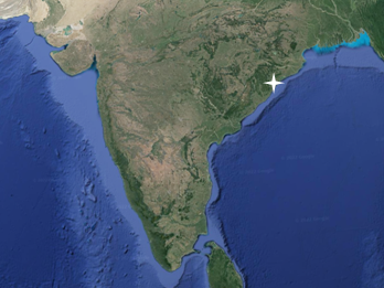
A careful analysis of Sugreeva’s descriptions makes it amply clear that Mt. Mahendra, which is at a distance of ~100 Yojana from Ravana’s Lanka is located at the southernmost tip of India, as opposed to Orrisa which is on the central-eastern side of the landmass.
Since the Mahendragiri of Orrisa does not corroborate the Ramayana description, where is Mt. Mahendra?
Just south of Agasthyamalai, after crossing the river Tamraparni and entering the Pandya land, we can find the hill named “Mahendragiri” in present-day Tamil Nadu.
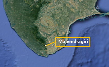
The location of this Mahendragiri perfectly corroborates Sugreeva’s description of Mahendra Parvat for his Vanara search party. Therefore, we can say, it is from this location that Hanuman crossed the ocean for ~100 Yojanas.
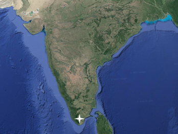
The Mahendra Parvat of Ramayana
What is the significance of this? How does it matter if Mt. Mahendra is in Orissa or Tamil Nadu?
Finding the location of Mt. Mahendra is crucial because it holds a key to the location of Ravana’s Lanka. How?
Regarding Mt. Mahendra, Sugreeva states that the island of Lanka is situated on the other/opposite side of the ocean.
द्वीपः तस्य अपरे पारे शत योजन विसृतः || ४-४१-२३
अगम्यो मानुषैः दीप्तः तम् मार्गध्वम् समंततः |
"There is a dazzling island on the other side of the shore of Mt. Mahendra, which is breadth wise a hundred Yojana-s, and which is an impassable one for humans, and you have to search that island up to its fringes.” [4-41-23b, 24a]
Next question arises, where is Ravana’s Lanka?
We shall find the answer in the upcoming parts of this series.
Notes:
1) Aiya VN (1906). “The Travancore State Manual”, Travancore Government Press. pp. 210–12.
Image courtesy: Google




Comments